A7: Find out how streets got their names
One of the most important clues to the history of an area comes from street names. Every street has one, but where do they come from? And what do they tell us about the past? Some are fairly obvious, such as High Street, or Church Street, or Cathedral Close. Others are not quite so obvious - I used to live in Hall Road, near Hall Yard and around the corner from Hall Place. Hall Farm is opposite us, and it is indeed farmed by a Mr Hall. But is he the person the roads are named after? Probably not - roads are rarely named after living people. So who was this Mr Hall that much of my village seems to be named after? What did he do that is deemed so worthy of remembering? And where do I find out who he was? Sounds like a good starting point for a local study.
Here is one street name that caught my attention. It is from Melton Mowbray in Leicestershire.
What were British schools? When were they built? Why were they built? What kind of education would you have received if you attended one? Were they free, or did you have to pay? Were they only in Melton Mowbray, or did they cover the whole country? Everybody knows few people went to school before 1870, don't they? Is this really true?
Here are another couple of names that might be of use. They are from Ilkeston, in Derbyshire.
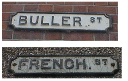
Who were these gentlemen? And why were the streets named after them? When were the houses built? (Clue - they were both Generals in World War One)
So, street names can raise as many questions as they can solve. Of course street names can also change, so it might be interesting to use the current map as a starting point, and then compare the names with some of the main roads on a much older map. For more information you might try: http://www.old-maps.co.uk/ where you should be able to download an old OS map of your neighbourhood.
Attached files:
- Local Street Names
551.5 KB PDF document